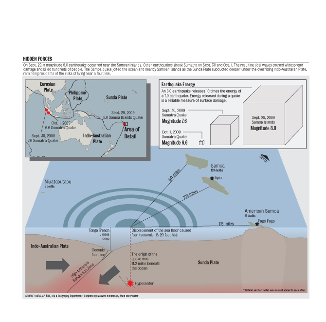
Throughout the past week, three high-magnitude earthquakes and a tsunami have rocked the Southeast Asian region, causing immense damage and loss of life.
On Sept. 29, a magnitude 8.0 quake shook Samoa, followed closely by a tsunami that consisted of four seismic waves, which resulted in the deaths of at least 170 people, according to The Associated Press.
Days later, undersea earthquakes of magnitudes 7.6 and 6.6 hit the Indonesian island of Sumatra, killing approximately 1,100 people.
With such similar disasters, it is a common misconception that the earthquakes in Indonesia and the combination quake and tsunami in Samoa are related in some fashion, perhaps as precursors to each other.
However, in spite of their relatively close proximity, the events have no correlation to each other, said UCLA geography professor Antony Orme.
Orme said that, although it is tempting to link the two, in any random district there is going to be clustering of quakes. This sentiment was echoed by geophysics professor David Jackson.
Jackson said that the events were separated by about 6,000 kilometers, making the stresses from the Samoan earthquake too small to trigger an event in Sumatra.
“Both Samoa and Sumatra are on very active plate boundaries that have had many earthquakes nearby for as far back as we have records,” he said. “We can’t predict the timing, but the occurrence of large earthquakes in both places is entirely expected.”
However, the two events do share one thing in common: the Indo-Australian Plate.
Orme said that the tectonic plate, which carries Australia and part of New Zealand, was involved in the proliferation of the quakes through a process called subduction.
During this process, one tectonic plate moves under another tectonic plate, forcing them to converge.
In this case, the Indo-Australian Plate’s movement against the Sunda Plate ““ which carries the Southeast Asian peninsula as well as Indonesia and Borneo ““ forced the Indo-Australian Plate to subduct, according to geophysics and geology professor Peter Bird.
This movement may have created vertical motion of the crust, resulting in the Samoan tsunami, Orme said.
The vertical motion consists of the up-and-down movement of the crust in the sea, which displaces a huge amount of water, he added.
“With subduction zones, tsunamis are a possibility,” he said, although he said that tsunamis are not specific solely to the Tongan area.
While Southern California is also known for its large earthquakes as well as its coastal location, the tsunami risk for the region is generally small.
Orme attributed this to the fact that the Northern California coast protects Southern California.
“Any coastal area should take this (tsunami) into consideration, but probably for Southern California, the chance is smaller,” he said.
However, Orme mentioned several examples of tsunamis that have come close to the state, including the 1964 Alaska earthquake, which generated a tsunami that moved outward from Anchorage and penetrated the coasts of Washington, Oregon and Northern California. As a result, several boats were washed away.
But in terms of the future of the Southeast Asian region, Orme expressed concern for the low-lying areas of the Pacific region.
“These areas could be swept away,” he said. “The reef environments may have been affected, and the danger of a tsunami is substantial.”
Jackson also mentioned the history of large earthquakes in the region ““ most recently, the 2004 magnitude 9.3 quake in Sumatra.
“I expect there will be more such earthquakes, nearby but not necessarily in the same places, over the next several years,” he said.
